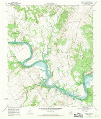
1968 Map of Brazos Point
USGS Topo · Published 1971About this map
The Brazos River carves a deep, winding path through this North Texas landscape, defining the boundaries between Somervell, Johnson, and Bosque counties. In the late 1960s, the southern portion of the map is dominated by the northern reaches of Lake Whitney, where the river broadens significantly at Kimball Bend. The topography is marked by distinctive limestone features like Bee Mtn, Butte, and Negrohead Bluff, which tower over the creek valleys.
Find a feature on this map
36 named features on this map. Tap any name to fly to it.
Don’t see what you’re looking for? This feature index may not catch every label — zoom into the map to look around manually.
Map Details
Editions of this 1968 Brazos Point Map
2 editions found
Other maps of this area

1889 · Granbury
USGS Topo · 1:125,000

1891 · Cleburne
USGS Topo · 1:125,000

1894 · Cleburne
USGS Topo · 1:125,000

1924 · Cleburne 3-B
USGS Topo · 1:48,000

1924 · Granbury 1-c
USGS Topo · 1:48,000

1924 · Cleburne 3-C
USGS Topo · 1:48,000

1924 · Granbury 4-a
USGS Topo · 1:48,000

1927 · Blum
USGS Topo · 1:62,500

1928 · Godley
USGS Topo · 1:62,500

1931 · Morgan
USGS Topo · 1:62,500