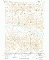
1952 Map of Brewster SW
USGS Topo · Published 1978About this map
Middle Loup River meanders across this mid-century Sandhills landscape, marking the central drainage of a region defined by broad valleys and scattered ranching infrastructure. The map reveals the intricate water management history of the area, featuring an Abandoned Canal that parallels the river's northern bank. To the south of the water, the remnants of early educational infrastructure are preserved in the form of School No 21 (Abandoned), a site of significant local genealogy interest. The terrain is structured by expansive flats including Brewster Valley and Edith Valley, while smaller tributaries like Rifle Creek feed into the primary river system. This survey, photoinspected in the 1970s but based on earlier 1950s data, illustrates the sparse settlement patterns and the enduring geography of the Dunning and Edith areas.
Find a feature on this map
8 named features on this map. Tap any name to fly to it.
Don’t see what you’re looking for? This feature index may not catch every label — zoom into the map to look around manually.
Map Details
Editions of this 1952 Brewster SW Map
3 editions found
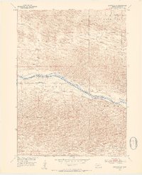
Other maps of this area

1948 · Linscott
USGS Topo · 1:62,500

1950 · Linscott
USGS Topo · 1:62,500

1951 · Dunning
USGS Topo · 1:62,500

1951 · Anselmo NE
USGS Topo · 1:24,000

1951 · Anselmo NW
USGS Topo · 1:24,000

1952 · Brewster
USGS Topo · 1:24,000

1952 · Brewster SE
USGS Topo · 1:24,000

1952 · Brewster SW
USGS Topo · 1:24,000

1952 · Brewster NW
USGS Topo · 1:24,000

1954 · North Platte
USGS Topo · 1:250,000