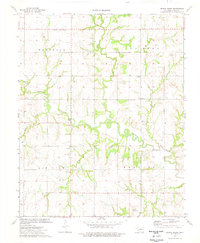
1974 Map of Bridge Creek
USGS Topo · Published 1977About this map
Skeleton Creek meanders through this portion of Logan County, defining a landscape marked by the transition from rural agricultural plots to active energy production. Significant 1970s oil activity is evidenced by numerous oil wells and a designated oil field scattered across the Oak View and Rose Hill sections. The cultural history of the area is anchored by quiet centers of community life, including the Mt Carmel Ch and early burying grounds such as Pleasant Ridge Cem and Victor Cem. Small clusters of settlement like Pleasant Hill and Midway sit near the convergence of drainage systems like Bridge Creek and Otter Creek. Further south, the Flying M Landing Strip and Simmering Park indicate localized development and recreational space within this traditional prairie-and-creek environment.
Find a feature on this map
26 named features on this map. Tap any name to fly to it.
Don’t see what you’re looking for? This feature index may not catch every label — zoom into the map to look around manually.
Map Details
Editions of this 1974 Bridge Creek Map
This is the sole edition of this map. No revisions or reprints were ever made.
Other maps of this area

1892 · Guthrie
USGS Topo · 1:62,500

1892 · Kingfisher
USGS Topo · 1:125,000

1893 · Mulhall
USGS Topo · 1:62,500

1893 · Lovell
USGS Topo · 1:62,500

1895 · Kingfisher
USGS Topo · 1:125,000

1954 · Oklahoma City
USGS Topo · 1:250,000

1955 · Enid
USGS Topo · 1:250,000

1957 · Oklahoma City
USGS Topo · 1:250,000

1958 · Enid
USGS Topo · 1:250,000

1963 · Oklahoma City
USGS Topo · 1:250,000