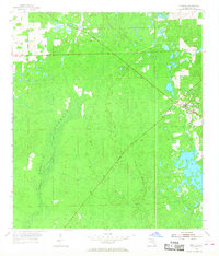
1954 Map of Bronson
USGS Topo · Published 1958About this map
Bronson serves as the primary focal point in this mid-century survey of the Florida interior, where the developed streets of the town give way to the dense wetlands of Devils Hammock. The landscape is defined by its low-lying drainage patterns, specifically the winding course of the Waccasassa River as it moves through the western half of the quadrangle. Transport history is etched into the terrain by the long diagonal of an Old Railroad Grade, which reflects the importance of timber and freight to the local economy before many of these rural lines were decommissioned. Near the eastern edge, the topography shifts slightly around Chunkey Pond, providing a distinct contrast to the more uniform swamp and hammock lands that dominate the surrounding Levy County territory.
Find a feature on this map
8 named features on this map. Tap any name to fly to it.
Don’t see what you’re looking for? This feature index may not catch every label — zoom into the map to look around manually.
Map Details
Editions of this 1954 Bronson Map
3 editions found
Other maps of this area

1954 · Chiefland
USGS Topo · 1:24,000

1954 · Otter Creek
USGS Topo · 1:24,000

1954 · Bronson
USGS Topo · 1:24,000

1954 · Bronson SW
USGS Topo · 1:24,000

1954 · Gainesville
USGS Topo · 1:250,000

1955 · Bronson NE
USGS Topo · 1:24,000

1955 · Bronson SE
USGS Topo · 1:24,000
1957 · Bronson SE
USGS Topo · 1:25,000

1958 · Gainesville
USGS Topo · 1:250,000

1959 · Gainesville
USGS Topo · 1:250,000