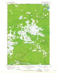
1953 Map of Brookston NW
USGS Topo · Published 1968About this map
The St Louis River defines the southern boundary of this St. Louis County landscape, where the Great Northern railroad tracks parallel the water's edge. Much of the southern terrain is occupied by the Fond Du Lac Indian Reservation, while the surrounding townships of Ness, Alborn, Arrowhead, and Culver contain a dense network of wetlands and small lakes. The map reveals early infrastructure like a Town Hall in the northwest and a Gravel Pit near the center of the sheet, indicating local resource extraction. Extensive water systems including Aerie Lake, Spider Lake, and Muskrat Lake dominate the central topography, connected by the winding path of Spider Creek. This survey captures the mid-century intersection of indigenous lands, industrial rail transport, and the natural drainage patterns of northern Minnesota.
Find a feature on this map
15 named features on this map. Tap any name to fly to it.
Don’t see what you’re looking for? This feature index may not catch every label — zoom into the map to look around manually.
Map Details
Editions of this 1953 Brookston NW Map
4 editions found
Other maps of this area

1953 · Payne
USGS Topo · 1:24,000

1953 · Alborn
USGS Topo · 1:24,000

1953 · Brookston
USGS Topo · 1:24,000

1953 · Brookston NW
USGS Topo · 1:24,000

1953 · Duluth
USGS Topo · 1:250,000

1954 · Martin Lake
USGS Topo · 1:24,000

1954 · Hibbing
USGS Topo · 1:250,000

1957 · Hibbing
USGS Topo · 1:250,000

1958 · Hibbing
USGS Topo · 1:250,000

1958 · Duluth
USGS Topo · 1:250,000