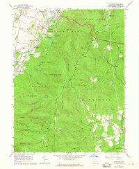
1964 Map of Brownfield
USGS Topo · Published 1965About this map
Industrial heritage and rugged topography define this section of Fayette County, where the rising slopes of Chestnut Ridge meet the coal-and-iron settlements of the valley. The map documents the footprint of early iron production at Wharton Furnace and the namesake Oliphant Furnace, alongside numerous Strip Mine operations and Gas Well locations that sustained the local economy in the mid-1960s. Transportation corridors are well-defined, including the historic National Road and the competing tracks of the Baltimore and Ohio and Pennsylvania railroads.
Find a feature on this map
64 named features on this map. Tap any name to fly to it.
Don’t see what you’re looking for? This feature index may not catch every label — zoom into the map to look around manually.
Map Details
Editions of this 1964 Brownfield Map
4 editions found
Other maps of this area

1900 · Uniontown
USGS Topo · 1:62,500

1900 · Masontown
USGS Topo · 1:62,500

1902 · Morgantown
USGS Topo · 1:62,500

1903 · Masontown
USGS Topo · 1:62,500

1904 · Bruceton
USGS Topo · 1:62,500

1925 · Morgantown
USGS Topo · 1:62,500

1926 · Bruceton
USGS Topo · 1:62,500

1931 · Uniontown
USGS Topo · 1:62,500

1931 · Masontown
USGS Topo · 1:62,500

1931 · Bruceton Mills
USGS Topo · 1:62,500
Featured Places
- South Union Township, PA
- North Union Township, PA
- Meadowbrook, South Union Township
- Wharton Township, PA
- Georges Township, PA