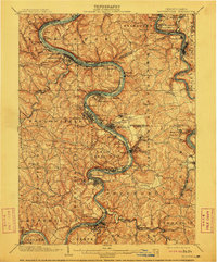
1906 Map of Brownsville
USGS Topo · Published 1911About this map
The Monongahela River and Youghiogheny River valleys dominate this industrial landscape at the turn of the century, revealing a region defined by coal extraction and river commerce. Steamboat-era river towns and early industrial centers like Monessen, Donora, and Charleroi line the riverbanks, supported by a dense network of railroads including the Pittsburgh & Lake Erie RR. The presence of the Vesta Mine and the aptly named Coal Center underscore the importance of the Monongahela coalfield during this era of rapid expansion.
Find a feature on this map
132 named features on this map. Tap any name to fly to it.
Don’t see what you’re looking for? This feature index may not catch every label — zoom into the map to look around manually.
Map Details
Editions of this 1906 Brownsville Map
4 editions found

Other maps of this area

1900 · Uniontown
USGS Topo · 1:62,500

1900 · Masontown
USGS Topo · 1:62,500

1901 · Amity
USGS Topo · 1:62,500

1901 · Waynesburg
USGS Topo · 1:62,500

1902 · Brownsville
USGS Topo · 1:62,500

1902 · Connellsville
USGS Topo · 1:62,500

1903 · Masontown
USGS Topo · 1:62,500

1904 · Amity
USGS Topo · 1:62,500

1904 · Mc Keesport
USGS Topo · 1:62,500

1904 · Waynesburg
USGS Topo · 1:62,500