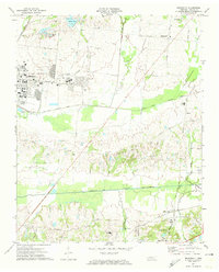
1971 Map of Brunswick
USGS Topo · Published 1974About this map
Millington and the surrounding Shelby County landscape appear in the early 1970s as a mix of major military installations and traditional rural crossroads. The U S Naval Air Station and U S Naval Hospital occupy the northwest, featuring a dense network of barracks, athletic fields, and a golf course. These modern facilities stand in contrast to the established community landmarks nearby, such as Bethlehem Ch and St James Cem Ch.
Find a feature on this map
61 named features on this map. Tap any name to fly to it.
Don’t see what you’re looking for? This feature index may not catch every label — zoom into the map to look around manually.
Map Details
Editions of this 1971 Brunswick Map
3 editions found
Other maps of this area

1942 · Millington
USGS Topo · 1:62,500

1943 · Collierville
USGS Topo · 1:62,500

1953 · Collierville
USGS Topo · 1:50,000

1954 · Mason
USGS Topo · 1:62,500

1956 · Blytheville
USGS Topo · 1:250,000

1959 · Blytheville
USGS Topo · 1:250,000

1960 · Bartlett
USGS Topo · 1:62,500

1960 · Millington
USGS Topo · 1:62,500

1961 · Bartlett
USGS Topo · 1:62,500

1965 · Brighton
USGS Topo · 1:24,000