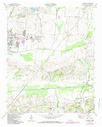
1971 Map of Brunswick
USGS Topo · Published 1984About this map
Millington and the expansive U S Naval Air Station anchor the western landscape of this 1971 study, which highlights a region defined by agricultural heritage and strategic military installations. Beyond the air station and its associated U S Naval Hospital, the terrain transitions into a patchwork of rural homesteads and smaller settlements like Brunswick, Bolton, and Rosemark. These communities are connected by a network of local thoroughfares such as Covington Pike and Old Brownsville Road, tracing paths through the drainage basins of the Loosahatchie River Drainage Canal and Big Creek Drainage Canal. Local genealogy is well-represented through numerous country churches and cemeteries, including Bethlehem Ch and the U S Naval Hospital Cem. The presence of the Illinois Central Gulf and Seaboard System railroads underscores the importance of rail transport to the local economy during this era of development in Shelby County.
Find a feature on this map
67 named features on this map. Tap any name to fly to it.
Don’t see what you’re looking for? This feature index may not catch every label — zoom into the map to look around manually.
Map Details
Editions of this 1971 Brunswick Map
3 editions found
Other maps of this area

1942 · Millington
USGS Topo · 1:62,500

1943 · Collierville
USGS Topo · 1:62,500

1953 · Collierville
USGS Topo · 1:50,000

1954 · Mason
USGS Topo · 1:62,500

1956 · Blytheville
USGS Topo · 1:250,000

1959 · Blytheville
USGS Topo · 1:250,000

1960 · Bartlett
USGS Topo · 1:62,500

1960 · Millington
USGS Topo · 1:62,500

1961 · Bartlett
USGS Topo · 1:62,500

1965 · Brighton
USGS Topo · 1:24,000