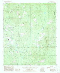
1986 Map of Bryceland
USGS Topo · Published 1986About this map
Bryceland sits at the center of this 1980s landscape, where the varied terrain of north-central Louisiana is defined by prominent elevations such as Driskill Mountain and Jordan Mountain. The area is characterized by a dense network of watercourses, including the meandering Saline Bayou, Bear Creek, and Choctaw Creek. These waterways and their surrounding valleys are punctuated by numerous industrial sites, notably several Sludge Pits and a Gravel Pit, reflecting the region's extraction and land-management activities during this era.
Find a feature on this map
24 named features on this map. Tap any name to fly to it.
Don’t see what you’re looking for? This feature index may not catch every label — zoom into the map to look around manually.
Map Details
Editions of this 1986 Bryceland Map
This is the sole edition of this map. No revisions or reprints were ever made.
Other maps of this area

1947 · Bienville
USGS Topo · 1:62,500

1948 · Jamestown
USGS Topo · 1:62,500

1949 · Jamestown
USGS Topo · 1:62,500

1949 · Bienville
USGS Topo · 1:62,500

1949 · Gibsland
USGS Topo · 1:62,500

1950 · Gibsland
USGS Topo · 1:62,500

1950 · Arcadia
USGS Topo · 1:62,500

1951 · Arcadia
USGS Topo · 1:62,500

1955 · Shreveport
USGS Topo · 1:250,000

1956 · Shreveport
USGS Topo · 1:250,000