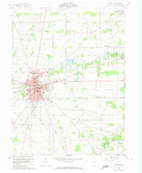
1960 Map of Bucyrus
USGS Topo · Published 1974About this map
The intersection of the Pennsylvania and New York Central railroads anchor the industrial and civic core of Bucyrus in this detailed 1960 survey. As the county seat, the city displays a dense network of neighborhood schools like Lincoln Sch and Norton Sch, while the city's eastern edge is dominated by the Fairground and the Sandusky River. Beyond the city limits, the landscape transitions into the agricultural townships of Holmes, Liberty, and Whetstone, where family and community history is preserved in numerous rural burial grounds such as Friends Cem and Stewart Cem. The northeastern corner highlights the village of Sulphur Springs, while the southern reaches show the early footprint of the Port Bucyrus Airport and the meandering headwaters of the Olentangy River.
Find a feature on this map
53 named features on this map. Tap any name to fly to it.
Don’t see what you’re looking for? This feature index may not catch every label — zoom into the map to look around manually.
Map Details
Editions of this 1960 Bucyrus Map
4 editions found
Other maps of this area

1903 · Marion
USGS Topo · 1:62,500

1905 · Marion
USGS Topo · 1:62,500

1906 · Sycamore
USGS Topo · 1:62,500

1913 · Mount Gilead
USGS Topo · 1:62,500

1915 · Bucyrus
USGS Topo · 1:62,500

1916 · Mount Gilead
USGS Topo · 1:62,500

1943 · Bucyrus
USGS Topo · 1:62,500

1943 · Mount Gilead
USGS Topo · 1:62,500

1950 · Marion
USGS Topo · 1:250,000

1960 · North Robinson
USGS Topo · 1:24,000