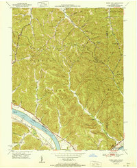
1951 Map of Buena Vista
USGS Topo · Published 1951About this map
The Ohio River dominates the southwestern corner of this mid-century landscape, where the Adams Co Lewis Co boundary follows the river's path. River navigation is anchored by Dam No 32, while the rugged hills above are largely preserved within the Shawnee State Forest. This area of the Ohio-Kentucky border reveals a network of small upland communities and rural landmarks, including the Twin Creek Lookout Tower perched on Blackburn Ridge. The topography is defined by narrow hollows and runs, such as Demazie Hollow and Buttermilk Fork, which dictate the placement of local settlements like Sunshine and Buena Vista. For genealogists, the map preserves the locations of vital community centers like Churn Creek Ch, the Twin Creek Mission, and Aills Chapel, alongside the dual naming of Rome (Stout PO).
Find a feature on this map
56 named features on this map. Tap any name to fly to it.
Don’t see what you’re looking for? This feature index may not catch every label — zoom into the map to look around manually.
Map Details
Editions of this 1951 Buena Vista Map
This is the sole edition of this map. No revisions or reprints were ever made.
Other maps of this area

1915 · Garrison
USGS Topo · 1:62,500

1915 · Otway
USGS Topo · 1:62,500

1916 · Peebles
USGS Topo · 1:62,500

1917 · Otway
USGS Topo · 1:62,500

1918 · Garrison
USGS Topo · 1:62,500

1918 · Peebles
USGS Topo · 1:62,500

1919 · Vanceburg
USGS Topo · 1:62,500

1949 · Pond Run
USGS Topo · 1:24,000

1949 · Vanceburg
USGS Topo · 1:62,500

1949 · Garrison
USGS Topo · 1:24,000