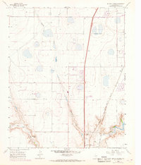
1960 Map of Buffalo Stadium
USGS Topo · Published 1968About this map
Spring Draw snakes through this Panhandle landscape, illustrating the hydrological patterns of Randall County before extensive modern development. The map highlights the intersection of transportation and recreation at the edge of the plains, where the Atchison Topeka and Santa Fe railroad line runs north toward Haney. A distinct social landscape is visible through the Canyon City Club and Palo Duro Club, which sit near the confluence of Tierra Blanca Creek and Palo Duro Creek. This 1960s survey provides a clear view of the area's rural character, punctuated by numerous well sites and local landmarks like Buffalo Stadium and the Memory Gardens cemetery. The terrain drops sharply toward the Prairie Dog Town Fork Red River, revealing the beginning of the canyon systems that define this region of Texas.
Find a feature on this map
47 named features on this map. Tap any name to fly to it.
Don’t see what you’re looking for? This feature index may not catch every label — zoom into the map to look around manually.
Map Details
Editions of this 1960 Buffalo Stadium Map
3 editions found
Other maps of this area

1954 · Tucumcari
USGS Topo · 1:250,000

1954 · Amarillo
USGS Topo · 1:250,000

1954 · Plainview
USGS Topo · 1:250,000

1954 · Clovis
USGS Topo · 1:250,000

1956 · Amarillo East
USGS Topo · 1:24,000

1958 · Clovis
USGS Topo · 1:250,000

1958 · Amarillo
USGS Topo · 1:250,000

1958 · Tucumcari
USGS Topo · 1:250,000

1958 · Plainview
USGS Topo · 1:250,000

1960 · Canyon
USGS Topo · 1:62,500