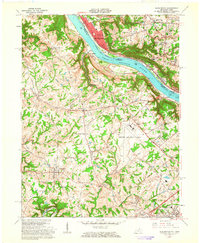
1961 Map of Burlington
USGS Topo · Published 1963About this map
The Ohio River carves a deep valley between the hills of northern Kentucky and the suburban expansion of Cincinnati, defining the geography of this 1961 survey. On the Kentucky side, the transition from rural Boone County to a regional transportation hub is evident in the sprawling grounds of the Greater Cincinnati Airport. The river remains a primary corridor for commerce and travel, featuring the active Anderson Ferry and the dual lines of the New York Central and Baltimore and Ohio railroads tracing the northern bank through Sayler Park and Delhi.
Find a feature on this map
59 named features on this map. Tap any name to fly to it.
Don’t see what you’re looking for? This feature index may not catch every label — zoom into the map to look around manually.
Map Details
Editions of this 1961 Burlington Map
3 editions found
Other maps of this area

1914 · West Cincinnati
USGS Topo · 1:62,500

1915 · Lawrenceburg
USGS Topo · 1:48,000

1928 · Lawrenceburg
USGS Topo · 1:62,500

1932 · Lawrenceburg
USGS Topo · 1:62,500

1943 · Rising Sun
USGS Topo · 1:24,000

1943 · Hooven
USGS Topo · 1:24,000

1943 · Lawrenceburg
USGS Topo · 1:24,000

1950 · Union
USGS Topo · 1:24,000

1950 · Independence
USGS Topo · 1:24,000

1950 · Covington
USGS Topo · 1:24,000