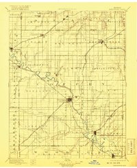
1894 Map of Burlington
USGS Topo · Published 1918About this map
The Neosho River and Marais des Cygnes Creek anchor this late-nineteenth-century survey of east-central Kansas, a landscape defined by its burgeoning rail network and agricultural townships. The town of Burlington serves as a central hub where the Missouri Kansas and Texas R. R. meets the A. T. and S. F. R. R. (Lawrence and Burlington Br.). This era saw the height of the steam rail system, with lines like the Mo. Pacif. R. R. (Kan. Neb. and Dak. Div.) and the Atchison Topeka and Santa Fe R. R. cutting across townships such as California and Pottawatomie. Smaller settlements like Arvonia, Ottumwa, and Agricola are meticulously recorded, showing their spatial relationship to the numerous watercourses like Long Creek and Eagle Creek. The map documents the intricate political boundaries of the time, including the convergence of Coffey, Lyon, and Osage counties.
Find a feature on this map
77 named features on this map. Tap any name to fly to it.
Don’t see what you’re looking for? This feature index may not catch every label — zoom into the map to look around manually.
Map Details
Editions of this 1894 Burlington Map
5 editions found

Other maps of this area

1885 · Eskridge
USGS Topo · 1:125,000

1885 · Burlington
USGS Topo · 1:125,000

1885 · Eureka
USGS Topo · 1:125,000

1885 · Garnett
USGS Topo · 1:125,000

1885 · Lawrence
USGS Topo · 1:125,000

1886 · Fredonia
USGS Topo · 1:125,000

1886 · Iola
USGS Topo · 1:125,000

1888 · Emporia
USGS Topo · 1:125,000

1888 · Eureka
USGS Topo · 1:125,000

1889 · Burlingame
USGS Topo · 1:125,000