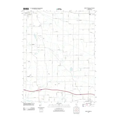
2012 Map of Burnt Prairie
USGS Topo · Published 2012About this map
Small rural hamlets and extensive petroleum infrastructure define this portion of Wayne County in the early 21st century. The landscape is a network of section-line roads, such as Co Rd 800 N, connecting dispersed family settlements and burial grounds including Kincheloe Cem and Atteberry Cem. The industrial footprint of the region is evident through the Clay City Oil Field and the Barnhill Oil Field, which coexist with traditional agricultural drainage patterns formed by Skillet Fork and Boyd Cr. From the southeastern edge of Fairfield to the village of Burnt Prairie, the map provides an essential record of local genealogy and land use, featuring landmarks like Dozier Airport and various rural crossings like Klines Corner and Merriam.
Find a feature on this map
74 named features on this map. Tap any name to fly to it.
Don’t see what you’re looking for? This feature index may not catch every label — zoom into the map to look around manually.
Map Details
Editions of this 2012 Burnt Prairie Map
This is the sole edition of this map. No revisions or reprints were ever made.
Other maps of this area

1940 · Carmi
USGS Topo · 1:62,500

1941 · Enfield
USGS Topo · 1:62,500

1943 · Carmi
USGS Topo · 1:62,500

1943 · Albion
USGS Topo · 1:62,500

1944 · Enfield
USGS Topo · 1:62,500

1946 · Albion
USGS Topo · 1:62,500

1948 · Fairfield
USGS Topo · 1:62,500

1958 · Belleville
USGS Topo · 1:250,000

1962 · Belleville
USGS Topo · 1:250,000
1970 · Geff
USGS Topo · 1:24,000