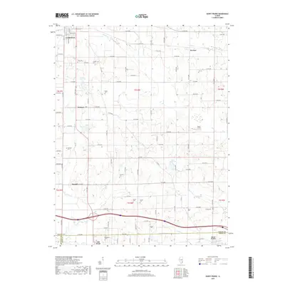
2018 Map of Burnt Prairie
USGS Topo · Published 2018About this map
Fairfield anchors the northwest corner of this Southern Illinois landscape, where the flat agricultural plains are carved by the meandering paths of Johnson Creek and Pond Creek. The map documents a dense network of family history and early settlement patterns, preserved through numerous rural burial grounds like Kincheloe Cemetery and Atteberry Cemetery. In the south, the terrain follows the flow of Boyd Creek near the community of Mill Shoals, while Burnt Prairie sits near the eastern boundary where Wayne and White counties meet.
Find a feature on this map
77 named features on this map. Tap any name to fly to it.
Don’t see what you’re looking for? This feature index may not catch every label — zoom into the map to look around manually.
Map Details
Editions of this 2018 Burnt Prairie Map
This is the sole edition of this map. No revisions or reprints were ever made.
Other maps of this area

1940 · Carmi
USGS Topo · 1:62,500

1941 · Enfield
USGS Topo · 1:62,500

1943 · Carmi
USGS Topo · 1:62,500

1943 · Albion
USGS Topo · 1:62,500

1944 · Enfield
USGS Topo · 1:62,500

1946 · Albion
USGS Topo · 1:62,500

1948 · Fairfield
USGS Topo · 1:62,500

1958 · Belleville
USGS Topo · 1:250,000

1962 · Belleville
USGS Topo · 1:250,000
1970 · Geff
USGS Topo · 1:24,000