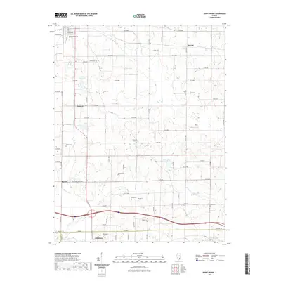
2021 Map of Burnt Prairie
USGS Topo · Published 2021About this map
Mill Shoals and Burnt Prairie anchor the southern portion of this Wayne and White County landscape, where the Skillet Fork valley transition is marked by a network of rural roads and small creek crossings. The terrain is defined by the winding paths of Pond Cr and Boyd Cr, which feed into the larger hydrological system near the southern boundary. To the north, the outskirts of Fairfield give way to a pastoral grid punctuated by several family-named burial grounds, including the Shaeffer Cem and Wright Cem. For researchers of local history, the map provides precise locations for scattered settlements like Barnhill and Merriam. Notable landmarks such as Dozier Airport and various small water bodies like Burkitt-Laws Lake and Briar Patch Lake offer a detailed look at the rural infrastructure and land use in this part of Southern Illinois.
Find a feature on this map
67 named features on this map. Tap any name to fly to it.
Don’t see what you’re looking for? This feature index may not catch every label — zoom into the map to look around manually.
Map Details
Editions of this 2021 Burnt Prairie Map
This is the sole edition of this map. No revisions or reprints were ever made.
Other maps of this area

1940 · Carmi
USGS Topo · 1:62,500

1941 · Enfield
USGS Topo · 1:62,500

1943 · Carmi
USGS Topo · 1:62,500

1943 · Albion
USGS Topo · 1:62,500

1944 · Enfield
USGS Topo · 1:62,500

1946 · Albion
USGS Topo · 1:62,500

1948 · Fairfield
USGS Topo · 1:62,500

1958 · Belleville
USGS Topo · 1:250,000

1962 · Belleville
USGS Topo · 1:250,000
1970 · Geff
USGS Topo · 1:24,000