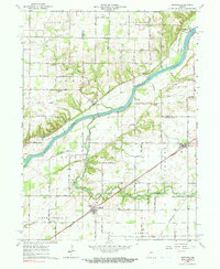
1962 Map of Burrows
USGS Topo · Published 1990About this map
Wabash River navigation and commerce define the landscape of this Carroll County region, which is marked by the historical path of the Erie Canal and the legacy of Towpath Road. The settlements of Lockport and Georgetown sit at the confluence of these waterways, while the Wabash RR and Pennsylvania Railroad later shifted the economic center towards inland towns like Burrows and Rockfield.
Find a feature on this map
35 named features on this map. Tap any name to fly to it.
Don’t see what you’re looking for? This feature index may not catch every label — zoom into the map to look around manually.
Map Details
Editions of this 1962 Burrows Map
3 editions found
Other maps of this area

1953 · Danville
USGS Topo · 1:250,000

1955 · Danville
USGS Topo · 1:250,000

1956 · Danville
USGS Topo · 1:250,000

1960 · Lucerne
USGS Topo · 1:24,000

1962 · Deer Creek
USGS Topo · 1:24,000

1962 · Flora
USGS Topo · 1:24,000

1962 · Burrows
USGS Topo · 1:24,000

1962 · Delphi
USGS Topo · 1:24,000

1962 · Burnettsville
USGS Topo · 1:24,000
1962 · Clymers
USGS Topo · 1:24,000