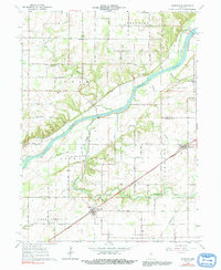
1962 Map of Burrows
USGS Topo · Published 1991About this map
The Wabash River carves a deep diagonal path through this Carroll County landscape, its banks lined with the remnants of early transportation and commerce. Near the river, Lockport sits along Towpath Road, a name that hints at the area's canal-era history, while the Wabash RR and Pennsylvania RR demonstrate the mid-20th-century dominance of rail transport. Settlement is concentrated in the small communities of Burrows and Rockfield, the latter featuring the IOOF Cem and several small gravel operations nearby.
Find a feature on this map
36 named features on this map. Tap any name to fly to it.
Don’t see what you’re looking for? This feature index may not catch every label — zoom into the map to look around manually.
Map Details
Editions of this 1962 Burrows Map
3 editions found
Other maps of this area

1953 · Danville
USGS Topo · 1:250,000

1955 · Danville
USGS Topo · 1:250,000

1956 · Danville
USGS Topo · 1:250,000

1960 · Lucerne
USGS Topo · 1:24,000

1962 · Deer Creek
USGS Topo · 1:24,000

1962 · Flora
USGS Topo · 1:24,000

1962 · Burrows
USGS Topo · 1:24,000

1962 · Delphi
USGS Topo · 1:24,000

1962 · Burnettsville
USGS Topo · 1:24,000
1962 · Clymers
USGS Topo · 1:24,000