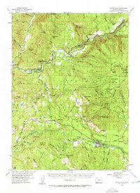
1954 Map of Butte Falls
USGS Topo · Published 1963About this map
Butte Falls serves as the focal point of this mid-century survey, situated at the junction of industrial and agricultural landscapes in Jackson County. The region is characterized by an extensive timber and water infrastructure, highlighted by the Medford Aqueduct Railroad and a Logging Railroad that trace the path of the Rogue River. Cultural markers from an earlier era are visible in the numerous educational sites, including the Elk Trail Sch and the then-vacant Derby Sch and Perry Sch.
Find a feature on this map
74 named features on this map. Tap any name to fly to it.
Don’t see what you’re looking for? This feature index may not catch every label — zoom into the map to look around manually.
Map Details
Editions of this 1954 Butte Falls Map
3 editions found
Other maps of this area

1891 · Ashland
USGS Topo · 1:250,000

1893 · Ashland
USGS Topo · 1:250,000

1897 · Ashland
USGS Topo · 1:250,000

1938 · Medford
USGS Topo · 1:125,000

1943 · Trail
USGS Topo · 1:62,500

1944 · Tiller
USGS Topo · 1:62,500

1944 · Abbott Butte
USGS Topo · 1:62,500

1947 · Abbott Butte
USGS Topo · 1:62,500

1954 · Medford
USGS Topo · 1:62,500

1954 · Butte Falls
USGS Topo · 1:62,500