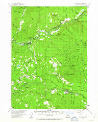
1954 Map of Butte Falls
USGS Topo · Published 1963About this map
Butte Falls serves as the industrial and civic anchor of this 1950s landscape, where the Medford Logging Railroad and various logging roads snake through the timberlands of the Rogue River National Forest. The map documents a period of transition in rural education and settlement, noting the Derby Sch and Perry Sch as abandoned, while the Elk Trail Sch remains. Along the Rogue River, recreational and conservation efforts are evident at McLeod State Park and Casey State Park, located near the settlement of McLeod. This survey provides a detailed look at the water management and agricultural infrastructure of the era, including the Medford water supply aqueducts, the Fish Hatchery, and scattered homesteads like the Cobleigh Ranch and Frendenburg Ranch.
Find a feature on this map
93 named features on this map. Tap any name to fly to it.
Don’t see what you’re looking for? This feature index may not catch every label — zoom into the map to look around manually.
Map Details
Editions of this 1954 Butte Falls Map
3 editions found
Other maps of this area

1891 · Ashland
USGS Topo · 1:250,000

1893 · Ashland
USGS Topo · 1:250,000

1897 · Ashland
USGS Topo · 1:250,000

1938 · Medford
USGS Topo · 1:125,000

1943 · Trail
USGS Topo · 1:62,500

1944 · Tiller
USGS Topo · 1:62,500

1944 · Abbott Butte
USGS Topo · 1:62,500

1947 · Abbott Butte
USGS Topo · 1:62,500

1954 · Medford
USGS Topo · 1:62,500

1954 · Butte Falls
USGS Topo · 1:62,500