1958 Map of Butte
USGS Topo · Published 1978About this map
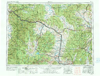
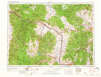
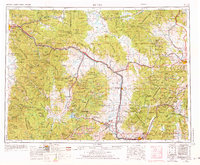
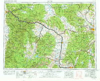
Industrial Montana takes center stage in this mid-century survey, anchored by the massive mining operations around Butte and the smelting centers of Anaconda and Opportunity. The map documents the heavy infrastructure of the era, from the sprawling Tailings pond to the dual transcontinental rail corridors of the Burlington Northern and the Milwaukee Road. The Continental Divide carves a path through the center of the sheet, separating the mountain settlements of the Garnet Range and Flint Creek Range from the state capital at Helena. Small mining and agricultural hubs like Marysville, Deer Lodge, and Drummond line the river valleys, while the Blackfoot River and Clark Fork provide the primary drainage for the complex high-country terrain. This 1970s revision reflects the completed reaches of Interstate 90, showing the modernization of the corridor connecting Missoula to the state's interior.
Find a feature on this map
77 named features on this map. Tap any name to fly to it.
Don’t see what you’re looking for? This feature index may not catch every label — zoom into the map to look around manually.
Map Details
Editions of this 1958 Butte Map
5 editions found

Other maps of this area

1886 · Great Falls
USGS Topo · 1:250,000

1886 · Fort Logan
USGS Topo · 1:250,000

1888 · Three Forks
USGS Topo · 1:250,000

1889 · Helena
USGS Topo · 1:250,000

1893 · Helena
USGS Topo · 1:250,000

1893 · Dillon
USGS Topo · 1:250,000

1894 · Three Forks
USGS Topo · 1:250,000

1895 · Three Forks
USGS Topo · 1:250,000

1899 · Boulder
USGS Topo · 1:125,000

1899 · Helena
USGS Topo · 1:62,500