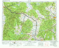
1958 Map of Butte
USGS Topo · Published 1978About this map
Butte and Helena anchor this expansive landscape where the industrial extraction of the Rockies meets the sweeping reaches of the Continental Divide. The heavy footprint of copper and silver mining is evident at the Open Pit Mine in Butte and the smelter works near Anaconda, while the surrounding terrain is defined by the Garnet Range and Sapphire Mountains. A complex transportation network ties these mountain settlements together, with the Northern Pacific RR and Chicago Milwaukee St Paul and Pacific RR tracing the river valleys alongside U.S. Highway 10. The map documents the mid-century intersection of massive federal landholdings, including the Deerlodge National Forest, with smaller mining camps and towns like Marysville and Deer Lodge. The presence of the Silver Gulch Cem near Helena provides a specific point of interest for those tracing the local history and genealogy of these Montana communities.
Find a feature on this map
69 named features on this map. Tap any name to fly to it.
Don’t see what you’re looking for? This feature index may not catch every label — zoom into the map to look around manually.
Map Details
Editions of this 1958 Butte Map
5 editions found

Other maps of this area

1886 · Great Falls
USGS Topo · 1:250,000

1886 · Fort Logan
USGS Topo · 1:250,000

1888 · Three Forks
USGS Topo · 1:250,000

1889 · Helena
USGS Topo · 1:250,000

1893 · Helena
USGS Topo · 1:250,000

1893 · Dillon
USGS Topo · 1:250,000

1894 · Three Forks
USGS Topo · 1:250,000

1895 · Three Forks
USGS Topo · 1:250,000

1899 · Boulder
USGS Topo · 1:125,000

1899 · Helena
USGS Topo · 1:62,500