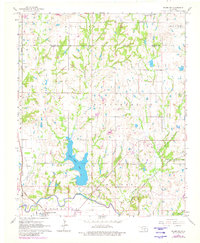
1965 Map of Byars SW
USGS Topo · Published 1980About this map
Washita River meanders along the southern edge of this Garvin County landscape, defining the topography near the Pauls Valley Oil Field. The 1960s survey illustrates a region where rural agricultural patterns meet industrial utility, evidenced by a Substation and the Atchison Topeka and Santa Fe railway corridor. Central to the map is the prominent Pauls Valley Lake, a significant water feature that breaks the transition between the townships of Stratford and Whitebead. Scattered rural community life is visible through institutions like the Free Holiness Ch, Bethel Ch, and the Paoli Cem. The presence of the Valley View Trailer Park and the settlement at Civit shows the localized residential clusters of the mid-20th century. Numerous creek systems, including Washington Creek and Owl Creek, drain the undulating terrain toward the river valley.
Find a feature on this map
29 named features on this map. Tap any name to fly to it.
Don’t see what you’re looking for? This feature index may not catch every label — zoom into the map to look around manually.
Map Details
Editions of this 1965 Byars SW Map
3 editions found
Other maps of this area

1898 · Pauls Valley
USGS Topo · 1:125,000

1902 · Pauls Valley
USGS Topo · 1:125,000

1957 · Ardmore
USGS Topo · 1:250,000

1963 · Ardmore
USGS Topo · 1:250,000

1964 · Byars
USGS Topo · 1:24,000

1965 · Pauls Valley NE
USGS Topo · 1:24,000
1965 · Rosedale
USGS Topo · 1:24,000

1965 · Byars SW
USGS Topo · 1:24,000
1965 · Wayne
USGS Topo · 1:24,000

1965 · Pauls Valley
USGS Topo · 1:24,000