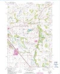
1974 Map of Cable
USGS Topo · Published 1993About this map
The St Cloud municipal boundary and the sprawling State Reformatory dominate the southwestern portion of this landscape, where urban growth meets the agricultural reaches of Minden and Haven townships. This 1974 survey captures a moment of transition as infrastructure expands eastward, highlighted by the St Cloud Municipal Airport and the Burlington Northern rail line cutting through the small settlement of Cable. Local industry is evidenced by numerous Quarries and a Quarry near the city limits, while the rural character remains intact through landmarks like St Patricks Ch and the winding course of the Elk River.
Find a feature on this map
24 named features on this map. Tap any name to fly to it.
Don’t see what you’re looking for? This feature index may not catch every label — zoom into the map to look around manually.
Map Details
Editions of this 1974 Cable Map
2 editions found
Other maps of this area

1950 · St. Cloud
USGS Topo · 1:62,500

1951 · Annandale
USGS Topo · 1:62,500

1953 · Saint Cloud
USGS Topo · 1:250,000

1953 · Stillwater
USGS Topo · 1:250,000

1955 · Stillwater
USGS Topo · 1:250,000

1957 · Saint Cloud
USGS Topo · 1:250,000

1958 · Stillwater
USGS Topo · 1:250,000

1958 · Saint Cloud
USGS Topo · 1:250,000

1961 · Clear Lake
USGS Topo · 1:24,000

1961 · Monticello
USGS Topo · 1:62,500