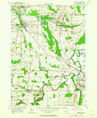
1950 Map of Caledonia
USGS Topo · Published 1964About this map
The Genesee River snakes through this 1950s landscape, serving as a natural divider between the townships of Caledonia and Avon. A dense network of legacy railroads, including the Erie RR, Pennsylvania RR, and the Baltimore and Ohio, converge near the established village of Caledonia, highlighting its importance as a regional transportation hub. Smaller hamlets such as Mumford, Canawaugus, and Fowlerville are depicted alongside their respective parish and community burial grounds, including the Scottish Cem and Mumford Rural Cem. The terrain is marked by numerous family-named landmarks like Collings Hill and Baker Hill, while industrial footprints are visible at the Quarry and Cement Plant Pond. This survey preserves the mid-century layout of country roads and school districts, such as School No 9, before modern developments altered the rural character of the Genesee Valley.
Find a feature on this map
58 named features on this map. Tap any name to fly to it.
Don’t see what you’re looking for? This feature index may not catch every label — zoom into the map to look around manually.
Map Details
Editions of this 1950 Caledonia Map
4 editions found
Other maps of this area

1895 · Rochester
USGS Topo · 1:62,500

1898 · Rochester
USGS Topo · 1:62,500

1899 · Brockport
USGS Topo · 1:62,500

1901 · Honeoye
USGS Topo · 1:62,500

1904 · Caledonia
USGS Topo · 1:62,500

1904 · Honeoye
USGS Topo · 1:62,500

1912 · Rochester
USGS Topo · 1:62,500

1920 · Rochester
USGS Topo · 1:62,500

1934 · Rush
USGS Topo · 1:24,000

1934 · Clifton
USGS Topo · 1:24,000