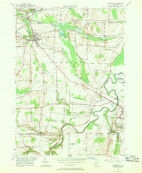
1950 Map of Caledonia
USGS Topo · Published 1970About this map
Caledonia and Avon serve as the primary hubs in this mid-century portrait of the Genesee Valley, where a dense network of five major railroads once converged. The Baltimore and Ohio, Lehigh Valley, New York Central, Erie RR, and Pennsylvania lines crisscross the landscape, illustrating the region's importance as a transportation corridor between major New York centers. Along the winding Genesee River, smaller settlements like Canawaugus, Fowlerville, and Ashantee remain distinct, often situated near significant water features like Avon Springs Downs and Horseshoe Pond. The map reveals a deeply rooted community structure, preserved through numerous local landmarks including Mumford Rural Cemetery, St Columbus Cemetery, and the Scottish Cemetery. From the industrial activity at the Quarry near Mumford to the educational centers like the High School in Caledonia, the survey captures the balance of agriculture, industry, and early suburban growth along the Oatka Creek drainage.
Find a feature on this map
50 named features on this map. Tap any name to fly to it.
Don’t see what you’re looking for? This feature index may not catch every label — zoom into the map to look around manually.
Map Details
Editions of this 1950 Caledonia Map
4 editions found
Other maps of this area

1895 · Rochester
USGS Topo · 1:62,500

1898 · Rochester
USGS Topo · 1:62,500

1899 · Brockport
USGS Topo · 1:62,500

1901 · Honeoye
USGS Topo · 1:62,500

1904 · Caledonia
USGS Topo · 1:62,500

1904 · Honeoye
USGS Topo · 1:62,500

1912 · Rochester
USGS Topo · 1:62,500

1920 · Rochester
USGS Topo · 1:62,500

1934 · Rush
USGS Topo · 1:24,000

1934 · Clifton
USGS Topo · 1:24,000