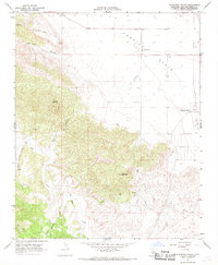
1966 Map of California Valley
USGS Topo · Published 1968About this map
Carrizo Plain and the surrounding high desert of eastern San Luis Obispo County are captured here during a period of mid-century development. While much of the landscape remains defined by the dramatic geology of Syncline Hill and Freeborn Mountain, the emergence of California Valley as a planned community is evident through its grid of roads and the California Valley Airfield. Near the established settlement of Simmler, the Carrisa Plains Sch serves as a vital community anchor for the ranching families of the area. The map traces the natural drainage of San Juan Creek and Anderson Canyon, juxtaposing these ancient watercourses against the human imprints of remote landing strips and isolated Drill Holes. This survey preserves the exact footprint of a unique California land venture before many of its proposed roads were fully realized.
Find a feature on this map
20 named features on this map. Tap any name to fly to it.
Don’t see what you’re looking for? This feature index may not catch every label — zoom into the map to look around manually.
Map Details
Editions of this 1966 California Valley Map
4 editions found
Other maps of this area

1912 · McKittrick
USGS Topo · 1:125,000

1932 · La Panza
USGS Topo · 1:48,000

1935 · La Panza
USGS Topo · 1:62,500

1936 · La Panza
USGS Topo · 1:62,500

1937 · Branch Mtn
USGS Topo · 1:48,000

1941 · Caliente Mountain
USGS Topo · 1:62,500

1942 · Branch Mountain
USGS Topo · 1:62,500

1942 · Caliente Mtn
USGS Topo · 1:62,500

1943 · Simmler
USGS Topo · 1:62,500

1943 · Caliente Mtn.
USGS Topo · 1:62,500