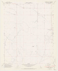
1966 Map of California Valley
USGS Topo · Published 1968About this map
Carriso Plain defines this portion of San Luis Obispo County, showing a sparse landscape of ranching and early mid-century infrastructure. The planned community of California Valley appears in its developing stages, marked by a systematic grid of unimproved dirt roads, a Po, and a Fire Sta. This area represents a unique attempt at interior California desert settlement, supported by the California Valley Airfield and a secondary Landing Strip to the northwest.
Find a feature on this map
21 named features on this map. Tap any name to fly to it.
Don’t see what you’re looking for? This feature index may not catch every label — zoom into the map to look around manually.
Map Details
Editions of this 1966 California Valley Map
4 editions found
Other maps of this area

1912 · McKittrick
USGS Topo · 1:125,000

1932 · La Panza
USGS Topo · 1:48,000

1935 · La Panza
USGS Topo · 1:62,500

1936 · La Panza
USGS Topo · 1:62,500

1937 · Branch Mtn
USGS Topo · 1:48,000

1941 · Caliente Mountain
USGS Topo · 1:62,500

1942 · Branch Mountain
USGS Topo · 1:62,500

1942 · Caliente Mtn
USGS Topo · 1:62,500

1943 · Simmler
USGS Topo · 1:62,500

1943 · Caliente Mtn.
USGS Topo · 1:62,500