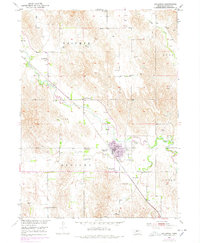
1951 Map of Callaway
USGS Topo · Published 1978About this map
Callaway serves as the focal point of this Custer County survey, situated at the confluence of the South Loup River and Sand Creek. The settlement's layout is defined by its relationship with the Union Pacific railroad, which follows the river's path through the valley. This mid-century study reveals a landscape heavily dotted with rural infrastructure, including a high density of country schools such as Evans Sch, Triumph Sch, and Whaley Sch serving the surrounding agricultural uplands. The terrain is divided into regional sections named Triumph, Ryno, and Delight, suggesting early local administrative or social districts. Genealogists will find significant value in the documentation of multiple burial grounds, including Rose Hill Cem and Kingsbury Cem, which alongside several flowing wells, illustrate the established agrarian life in central Nebraska during this era.
Find a feature on this map
26 named features on this map. Tap any name to fly to it.
Don’t see what you’re looking for? This feature index may not catch every label — zoom into the map to look around manually.
Map Details
Editions of this 1951 Callaway Map
3 editions found
Other maps of this area

1951 · Callaway NW
USGS Topo · 1:24,000

1951 · Merna
USGS Topo · 1:24,000

1951 · Callaway SE
USGS Topo · 1:24,000

1951 · Callaway
USGS Topo · 1:24,000

1951 · Oconto NW
USGS Topo · 1:24,000

1951 · Oconto
USGS Topo · 1:24,000

1954 · North Platte
USGS Topo · 1:250,000

1955 · Broken Bow
USGS Topo · 1:250,000

1956 · Broken Bow
USGS Topo · 1:250,000

1956 · North Platte
USGS Topo · 1:250,000