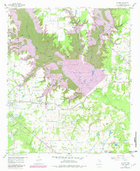
1959 Map of Calvary
USGS Topo · Published 1982About this map
The Lake Fork Reservoir dominates this Wood County landscape, shown here during a transitional phase with the planned normal pool level marked over the valley of Lake Fork Creek. The region’s economic history is etched into the terrain through various extraction sites, including the Quitman Oil Field, the Alba Oil Field, and several locations labeled as Old Mining Area. These industrial footprints contrast with the established rural character of communities like Salem and Alba, which are connected by a network of drainage systems such as Little Mustang Creek and Williams Creek. Researchers can trace the lineage of local families through rural landmarks like Searcy Cem and Pleasant Ridge Cem, or examine the remnants of transportation history along the Old Railroad Grade that cuts across the southern portion of the map near Calvary. Several churches, including Enon Ch and Pilgrims Rest No 2 Ch, serve as anchors for these long-standing rural settlements.
Find a feature on this map
38 named features on this map. Tap any name to fly to it.
Don’t see what you’re looking for? This feature index may not catch every label — zoom into the map to look around manually.
Map Details
Editions of this 1959 Calvary Map
4 editions found
Other maps of this area

1956 · Tyler
USGS Topo · 1:250,000

1958 · Arbala
USGS Topo · 1:24,000

1958 · Alba
USGS Topo · 1:24,000

1959 · Calvary
USGS Topo · 1:24,000

1959 · Golden
USGS Topo · 1:24,000

1959 · Grand Saline
USGS Topo · 1:24,000

1959 · Yantis
USGS Topo · 1:24,000

1959 · Grand Saline
USGS Topo · 1:62,500

1959 · Alba
USGS Topo · 1:62,500

1960 · Mineola
USGS Topo · 1:24,000