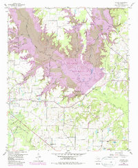
1959 Map of Calvary
USGS Topo · Published 1987About this map
The Lake Fork Reservoir dominates the northern landscape of Wood County in this 1959 study, which was updated in 1981 to show the planned pool of the reservoir inundating the valleys of Lake Fork Creek and Little Caney Creek. This intersection of industrial history and civil engineering reveals an area in transition. In the western portion, the Alba Oil Field and scattered Old Mining Areas sit near an Old Railroad Grade, marking the region's extraction-based economy. To the south and east, the rural character remains centered around small community hubs such as Alba and Calvary. Local genealogy is well-preserved through numerous country churches and burial grounds, including Enon Ch, Pleasant Ridge Ch, and the Searcy Cem, providing a clear record of family settlements before the expansion of the reservoir altered the terrain.
Find a feature on this map
40 named features on this map. Tap any name to fly to it.
Don’t see what you’re looking for? This feature index may not catch every label — zoom into the map to look around manually.
Map Details
Editions of this 1959 Calvary Map
4 editions found
Other maps of this area

1956 · Tyler
USGS Topo · 1:250,000

1958 · Arbala
USGS Topo · 1:24,000

1958 · Alba
USGS Topo · 1:24,000

1959 · Calvary
USGS Topo · 1:24,000

1959 · Golden
USGS Topo · 1:24,000

1959 · Grand Saline
USGS Topo · 1:24,000

1959 · Yantis
USGS Topo · 1:24,000

1959 · Grand Saline
USGS Topo · 1:62,500

1959 · Alba
USGS Topo · 1:62,500

1960 · Mineola
USGS Topo · 1:24,000