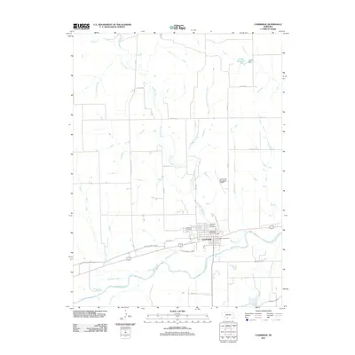
2011 Map of Cambridge
USGS Topo · Published 2011About this map
Cambridge serves as the primary hub in this southwestern Nebraska landscape, where the confluence of managed waterways and natural drainage systems defines the local geography. The city is situated just north of the Republican River, which flows across the southern portion of the sheet. Vital irrigation and water management infrastructure, including the Red Willow Canal and the Bartley Canal, underscore the region's agricultural reliance on redirected water. To the northeast, the Joseph Reservoir and Joseph Dam indicate a landscape heavily modified for conservation or irrigation purposes.
Find a feature on this map
28 named features on this map. Tap any name to fly to it.
Don’t see what you’re looking for? This feature index may not catch every label — zoom into the map to look around manually.
Map Details
Editions of this 2011 Cambridge Map
This is the sole edition of this map. No revisions or reprints were ever made.
Other maps of this area

1954 · McCook
USGS Topo · 1:250,000

1956 · Freedom
USGS Topo · 1:24,000

1956 · Cambridge
USGS Topo · 1:24,000

1956 · Medicine Creek Dam
USGS Topo · 1:24,000

1956 · Bartley
USGS Topo · 1:24,000

1957 · McCook
USGS Topo · 1:250,000

1957 · Danbury NE
USGS Topo · 1:24,000

1958 · McCook
USGS Topo · 1:250,000

1958 · Danbury NE
USGS Topo · 1:24,000
1958 · Wilsonville NW
USGS Topo · 1:24,000