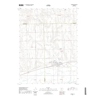
2017 Map of Cambridge
USGS Topo · Published 2017About this map
Cambridge serves as the central hub of this agricultural landscape in Southwest Nebraska, situated along the northern bank of the Republican River. The town layout is clearly defined, with residential streets like Niobrara St and Nakoma St bordering the Railway St corridor. The surrounding terrain is deeply carved by drainage systems including Medicine Creek, Little Medicine Creek, and Richmond Creek, illustrating the complex hydrology required to support regional farming. To the west of the main settlement lies Fairview and the adjacent Fairview Cem, while the Cambridge Municipal Airport sits on the bluffs to the north. Evidence of large-scale water management is present in the Red Willow Canal and Bartley Canal, which parallel the river valley to facilitate irrigation across the Furnas Co and Red Willow Co border.
Find a feature on this map
50 named features on this map. Tap any name to fly to it.
Don’t see what you’re looking for? This feature index may not catch every label — zoom into the map to look around manually.
Map Details
Editions of this 2017 Cambridge Map
This is the sole edition of this map. No revisions or reprints were ever made.
Other maps of this area

1954 · McCook
USGS Topo · 1:250,000

1956 · Freedom
USGS Topo · 1:24,000

1956 · Cambridge
USGS Topo · 1:24,000

1956 · Medicine Creek Dam
USGS Topo · 1:24,000

1956 · Bartley
USGS Topo · 1:24,000

1957 · McCook
USGS Topo · 1:250,000

1957 · Danbury NE
USGS Topo · 1:24,000

1958 · McCook
USGS Topo · 1:250,000

1958 · Danbury NE
USGS Topo · 1:24,000
1958 · Wilsonville NW
USGS Topo · 1:24,000