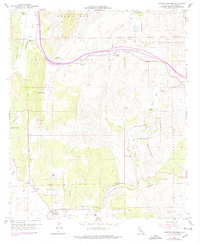
1959 Map of Cameron Corners
USGS Topo · Published 1978About this map
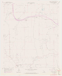
Cleveland National Forest dominates this landscape in southern San Diego County, where the high terrain of the Laguna Mts transitions into the Campo Valley. The map documents a sparsely populated but critical transportation corridor during the late 1950s, defined by the winding path of La Posta Creek and the tracks of the San Diego and Arizona Eastern railroad. Small outposts and seasonal ranches like Boulder Oaks, Miller Ranch, and La Posta Ranch are scattered throughout, alongside civil infrastructure including the Cameron Guard Sta and a Heliport. Tribal lands occupy significant portions of the area, notably the La Posta Indian Reservation and the Campo Indian Reservation. The presence of several Gravel Pits and the Clover Flat Pit suggest the local importance of resource extraction within this mountain landscape, while a small Cem near Cameron Corners provides a focal point for genealogical interest.
Find a feature on this map
38 named features on this map. Tap any name to fly to it.
Don’t see what you’re looking for? This feature index may not catch every label — zoom into the map to look around manually.
Map Details
Editions of this 1959 Cameron Corners Map
7 editions found
Other maps of this area

1903 · Cuyamaca
USGS Topo · 1:125,000

1904 · Southern California Sheet No. 2
USGS Topo · 1:250,000

1931 · Carrizo
USGS Topo · 1:125,000

1939 · Campo
USGS Topo · 1:62,500

1942 · Potrero
USGS Topo · 1:48,000

1942 · Campo
USGS Topo · 1:62,500

1942 · Cuyapaipe
USGS Topo · 1:62,500

1942 · Cuyamaca Peak
USGS Topo · 1:62,500

1944 · Potrero
USGS Topo · 1:62,500

1944 · Cuyamaca Peak
USGS Topo · 1:62,500