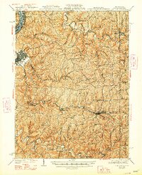
1942 Map of Cameron
USGS Topo · Published 1948About this map
The Ohio River forms the western boundary of this Marshall County landscape, where the Baltimore and Ohio RR hugs the shoreline through McMechen and The Narrows. Moving inland, the terrain transitions into a dense network of ridges and hollows, characteristic of the northern West Virginia panhandle during the mid-20th century. The settlement at Moundsville stands as a primary hub, while the interior is defined by rural communities and essential social infrastructure, including the Wood Hill Ch and a high density of country schools like Squirrel Alley Sch and Nauvoo Sch.
Find a feature on this map
113 named features on this map. Tap any name to fly to it.
Don’t see what you’re looking for? This feature index may not catch every label — zoom into the map to look around manually.
Map Details
Editions of this 1942 Cameron Map
2 editions found

Other maps of this area

1902 · Wheeling
USGS Topo · 1:62,500

1903 · Littleton
USGS Topo · 1:62,500

1904 · Cameron
USGS Topo · 1:62,500

1905 · Mannington
USGS Topo · 1:62,500

1905 · Rogersville
USGS Topo · 1:62,500

1905 · Littleton
USGS Topo · 1:62,500

1905 · Clarington
USGS Topo · 1:62,500

1905 · St. Clairsville
USGS Topo · 1:62,500

1906 · New Martinsville
USGS Topo · 1:62,500

1907 · Claysville
USGS Topo · 1:62,500