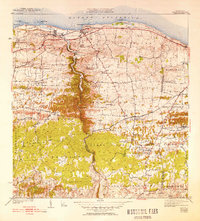
1942 Map of Camuy
USGS Topo · Published 1952About this map
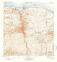
Camuy and Hatillo anchor the northern coastline of this 1940s survey, where the American R R of Porto Rico parallels the shore of the Oceano Atlantico. The landscape is defined by the deep carving of the Rio Camuy, which winds through varied terrain types including the Cienagas and Abra Honda. Inland, the map reveals a dense network of mountain communities and family-named roads like Camino Matojillo and Camino de la Cuesta. This era captures a distinct transition as the coastal rail economy served agricultural sectors, evidenced by the Salto Maquina and various local stations. Cultural landmarks are prominent throughout the barrios, including the Iglesia Santa Teresita and Iglesia de Dios Pentecostal, providing a look at the social heart of rural settlements like Campo Alegre and Pueblo Nuevo before mid-century modernization.
Find a feature on this map
76 named features on this map. Tap any name to fly to it.
Don’t see what you’re looking for? This feature index may not catch every label — zoom into the map to look around manually.
Map Details
Editions of this 1942 Camuy Map
6 editions found
Other maps of this area

1938 · Camuy
USGS Topo · 1:20,000

1938 · San Sebastian
USGS Topo · 1:20,000

1938 · Quebradillas
USGS Topo · 1:20,000

1941 · San Sebastian
USGS Topo · 1:30,000

1942 · Arecibo
USGS Topo · 1:30,000

1942 · Camuy
USGS Topo · 1:30,000

1946 · Utuado
USGS Topo · 1:30,000

1946 · Bayaney
USGS Topo · 1:30,000

1946 · Arecibo
USGS Topo · 1:30,000
1947 · Arecibo SO
USGS Topo · 1:10,000