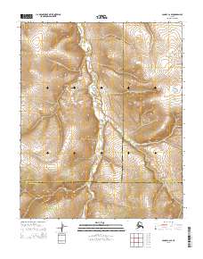
2015 Map of Candle C-2 SE
USGS Topo · Published 2015About this map
South Fork Buckland River winds through this interior landscape, defining the central drainage system of the region. The map documents a significant intersection of administrative borders where the Northwest Arctic Borough, Yukon-Koyukuk Census Area, and Nome Census Area meet. This convergence of jurisdictions underscores the remote nature of the territory, where vast stretches of wilderness are partitioned by lines of census and borough authority rather than by road networks or urban centers. The terrain is characterized by the intricate elevations of the surrounding highlands, with the S Fork Buckland River serving as the primary geographical anchor for the public land survey system divisions.
Find a feature on this map
11 named features on this map. Tap any name to fly to it.
Don’t see what you’re looking for? This feature index may not catch every label — zoom into the map to look around manually.
Map Details
Editions of this 2015 Candle C-2 SE Map
This is the sole edition of this map. No revisions or reprints were ever made.
Other maps of this area

1951 · Candle
USGS Topo · 1:250,000

1954 · Candle C-2
USGS Topo · 1:63,360

1954 · Candle B-2
USGS Topo · 1:63,360

1954 · Candle C-1
USGS Topo · 1:63,360

1954 · Candle B-1
USGS Topo · 1:63,360

1955 · Candle
USGS Topo · 1:250,000

1964 · Candle
USGS Topo · 1:250,000
2014 · Candle B-2 NW
USGS Topo · 1:25,000
2014 · Candle C-2 NW
USGS Topo · 1:25,000
2014 · Candle C-2 SW
USGS Topo · 1:25,000