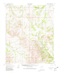
1950 Map of Candle C-5
USGS Topo · Published 1981About this map
Weather Ridge dominates the western portion of this 1950s interior landscape, a terrain defined by an intricate network of waterways draining toward the Arctic. The presence of a Landing Strip and a prominent Tractor Trail cutting through the valleys of Quartz Creek and Deer Creek indicates the essential role of specialized transport in this remote territory. This period of mapping captured a transition in the Alaskan wilderness where industrial-era machinery began to follow the same drainages used by earlier explorers and indigenous travelers. Sparse human presence is noted only by scattered Cabins and a lone Cabin near the southern boundary, suggesting temporary camps for hunting or mineral prospecting rather than permanent settlements. Large water bodies like Fairhaven Creek and Kilukikpuk Creek anchor the hydrology of the region, while smaller tributaries like Sugar Loaf Creek and Cape Horne Creek highlight the detailed surveying effort of the era.
Find a feature on this map
29 named features on this map. Tap any name to fly to it.
Don’t see what you’re looking for? This feature index may not catch every label — zoom into the map to look around manually.
Map Details
Editions of this 1950 Candle C-5 Map
3 editions found
Other maps of this area

1950 · Candle C-5
USGS Topo · 1:63,360

1950 · Candle B-5
USGS Topo · 1:63,360

1950 · Candle B-6
USGS Topo · 1:63,360

1950 · Candle C-6
USGS Topo · 1:63,360

1951 · Candle
USGS Topo · 1:250,000

1951 · Candle D-5
USGS Topo · 1:63,360

1951 · Candle D-6
USGS Topo · 1:63,360

1955 · Candle
USGS Topo · 1:250,000

1955 · Candle D-4
USGS Topo · 1:63,360

1955 · Candle C-4
USGS Topo · 1:63,360