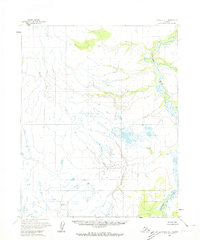
1954 Map of Candle D-1
USGS Topo · Published 1974About this map
The Tagagawik River meanders through this remote interior landscape in the mid-1950s, creating a complex network of oxbow lakes and wetlands across the low-lying terrain. The map is defined by its lack of established roads or permanent settlements, reflecting the wilderness character of the region during this era of topographic survey. Instead of towns, the sheet highlights specific surveyor and topographic markers such as Wrench North Base, Wrench South Base, and the named elevation point Andy. These markers, along with the Middle Fork drainage, provide the primary spatial orientation in a territory dominated by water and high-relief tundra. The mapping by the Geological Survey relies heavily on photogrammetric methods from aerial photography, emphasizing the importance of these geodetic points for establishing control in the Alaskan interior.
Find a feature on this map
5 named features on this map. Tap any name to fly to it.
Don’t see what you’re looking for? This feature index may not catch every label — zoom into the map to look around manually.
Map Details
Editions of this 1954 Candle D-1 Map
2 editions found
Other maps of this area

1951 · Candle
USGS Topo · 1:250,000

1951 · Selawik
USGS Topo · 1:250,000

1951 · Shungnak
USGS Topo · 1:250,000

1951 · Kateel River
USGS Topo · 1:250,000

1954 · Candle C-2
USGS Topo · 1:63,360
1954 · Candle D-1
USGS Topo · 1:63,360

1954 · Candle C-1
USGS Topo · 1:63,360

1954 · Kateel River D-6
USGS Topo · 1:63,360

1954 · Candle D-2
USGS Topo · 1:63,360

1954 · Kateel River C-6
USGS Topo · 1:63,360