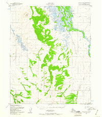
1951 Map of Candle D-5
USGS Topo · Published 1960About this map
Buckland stands as the primary focus of this Alaskan survey, situated along the winding banks of the Buckland River. This mid-century interior landscape is defined by its complex drainage systems, where Kanik Creek and Koobuk Creek feed into the larger river network. To the west, the terrain rises significantly toward Clem Mountain, while the southern reaches are marked by the prominence of Sugar Top.
Find a feature on this map
14 named features on this map. Tap any name to fly to it.
Don’t see what you’re looking for? This feature index may not catch every label — zoom into the map to look around manually.
Map Details
Editions of this 1951 Candle D-5 Map
3 editions found
Other maps of this area

1950 · Candle C-5
USGS Topo · 1:63,360

1950 · Candle C-6
USGS Topo · 1:63,360

1951 · Candle
USGS Topo · 1:250,000

1951 · Selawik
USGS Topo · 1:250,000

1951 · Candle D-5
USGS Topo · 1:63,360

1951 · Selawik A-5
USGS Topo · 1:63,360

1951 · Candle D-6
USGS Topo · 1:63,360

1951 · Selawik A-6
USGS Topo · 1:63,360

1955 · Candle
USGS Topo · 1:250,000

1955 · Selawik A-4
USGS Topo · 1:63,360