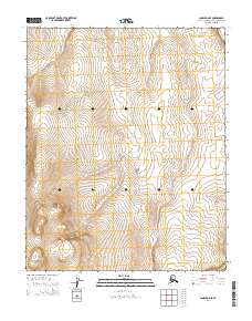
2014 Map of Candle D-5 SE
USGS Topo · Published 2014About this map
Fairhaven Cr defines the central and northern drainage of this landscape in the Northwest Arctic Borough, flowing through the unorganized territory toward the northern edge of the sheet. In the extreme northeastern corner, the Buckland River appears briefly, serving as a primary watercourse in this region of the Seward Peninsula. The map is primarily characterized by the Public Land Survey System grid, which divides the terrain into townships including t6n r12w, t6n r11w, and t4n r12w. The contour lines reveal a complex topography of rising elevations and drainage basins away from the primary creeks, providing a clear picture of the hydrological patterns and elevation changes in this part of Alaska during the early twenty-first century.
Find a feature on this map
8 named features on this map. Tap any name to fly to it.
Don’t see what you’re looking for? This feature index may not catch every label — zoom into the map to look around manually.
Map Details
Editions of this 2014 Candle D-5 SE Map
This is the sole edition of this map. No revisions or reprints were ever made.
Other maps of this area

1950 · Candle C-5
USGS Topo · 1:63,360

1951 · Candle
USGS Topo · 1:250,000

1951 · Candle D-5
USGS Topo · 1:63,360

1955 · Candle
USGS Topo · 1:250,000

1955 · Candle D-4
USGS Topo · 1:63,360

1955 · Candle C-4
USGS Topo · 1:63,360

1964 · Candle
USGS Topo · 1:250,000
2014 · Candle C-5 NW
USGS Topo · 1:25,000
2014 · Candle C-5 NE
USGS Topo · 1:25,000
2014 · Candle D-5 SW
USGS Topo · 1:25,000