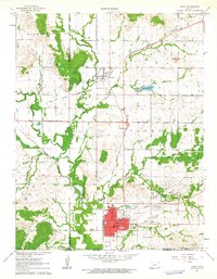
1961 Map of Caney
USGS Topo · Published 1963About this map
The Old Indian Treaty Boundary cuts across this southeastern Kansas landscape, marking a significant historical line through Montgomery and Chautauqua counties. The city of Caney serves as a local hub near the Oklahoma border, shown here during a period of transition in its industrial and transit infrastructure. Evidence of the region's energy history is visible at the Tank Farm (Abandoned) and various oil wells scattered across the terrain, while the Little Caney River and its tributaries like Cheyenne Creek define the drainage patterns.
Find a feature on this map
31 named features on this map. Tap any name to fly to it.
Don’t see what you’re looking for? This feature index may not catch every label — zoom into the map to look around manually.
Map Details
Editions of this 1961 Caney Map
3 editions found
Other maps of this area

1885 · Sedan
USGS Topo · 1:125,000

1886 · Independence
USGS Topo · 1:125,000

1889 · Sedan
USGS Topo · 1:125,000

1894 · Independence
USGS Topo · 1:125,000

1901 · Nowata
USGS Topo · 1:125,000

1905 · Independence
USGS Topo · 1:125,000

1909 · Pawhuska
USGS Topo · 1:125,000

1910 · Pawhuska
USGS Topo · 1:125,000

1914 · Nowata
USGS Topo · 1:125,000

1947 · Joplin
USGS Topo · 1:250,000