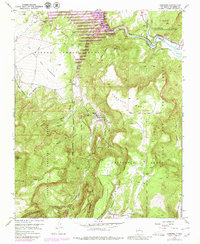
1953 Map of Canones
USGS Topo · Published 1980About this map
The high mesas and narrow valleys of Rio Arriba County are defined here by a series of massive land grants and remote ranching settlements. The small village of Cañones serves as a focal point, situated along the Cañones Creek where the Capilla de San Miguel and the Cañones Grade School represent the community's mid-century civic and spiritual heart. The geography is characterized by dramatic elevation changes, moving from the banks of the Rio Chama and the Abeyta Trujillo Ditch in the north up to the high heights of Cerro Pedernal and Escoba Mesa in the south.
Find a feature on this map
39 named features on this map. Tap any name to fly to it.
Don’t see what you’re looking for? This feature index may not catch every label — zoom into the map to look around manually.
Map Details
Editions of this 1953 Canones Map
4 editions found
Other maps of this area

1909 · Gallina
USGS Topo · 1:125,000

1918 · Abiquiu
USGS Topo · 1:125,000

1953 · Canones
USGS Topo · 1:24,000

1953 · Cerro Del Grant
USGS Topo · 1:24,000

1953 · Abiquiu
USGS Topo · 1:24,000

1953 · Vallecitos
USGS Topo · 1:24,000

1953 · Polvadera Peak
USGS Topo · 1:24,000

1953 · Echo Ampitheater
USGS Topo · 1:24,000

1953 · Canjilon SE
USGS Topo · 1:24,000

1953 · Youngsville
USGS Topo · 1:24,000