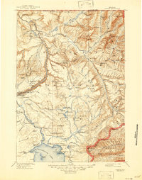
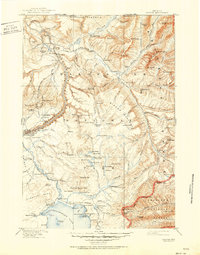
1911 Map of Canyon
USGS Topo · Published 1946About this map
Yellowstone National Park reveals its early 20th-century character through a network of stage roads and iconic tourist lodgings before the era of modern pavement. Centered on the Grand Canyon Of The Yellowstone, this map showcases the establishment of the early park experience at the Canyon Hotel and Canyon Lodge. The transition from frontier outpost to managed park is evident in sites like Yanceys and the Roosevelt Lodge, along with various remote snowshoe cabins used by early rangers for winter patrols. Geothermal features are meticulously noted, ranging from the well-known Dragons Mouth Spr and Mad Volcano to the clustered vents of The Mudkettles and Mushpots. Along the northern edge, the Buffalo Ranch and the Fossil Forest highlight the early focus on wildlife conservation and geological preservation during this formative era of federal land management.
Find a feature on this map
99 named features on this map. Tap any name to fly to it.
Don’t see what you’re looking for? This feature index may not catch every label — zoom into the map to look around manually.
Map Details
Editions of this 1911 Canyon Map
6 editions found

Other maps of this area

1885 · Lake
USGS Topo · 1:125,000

1885 · Gallatin
USGS Topo · 1:125,000

1885 · Gallatin
USGS Topo · 1:125,000

1886 · Shoshone
USGS Topo · 1:125,000

1886 · Canyon
USGS Topo · 1:125,000

1888 · Shoshone
USGS Topo · 1:125,000

1891 · Livingston
USGS Topo · 1:250,000

1893 · Livingston
USGS Topo · 1:250,000

1893 · Ishawooa
USGS Topo · 1:125,000

1895 · Shoshone
USGS Topo · 1:125,000