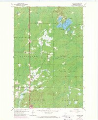
1953 Map of Canyon
USGS Topo · Published 1971About this map
The settlement of Canyon serves as a focal point in this St. Louis County landscape, situated near the headwaters of Hellwig Creek and the southern reaches of Northland. This mid-century survey reveals a region defined by its timber and water resources, with significant portions of the terrain dedicated to the Cloquet Valley State Forest. Local infrastructure is concentrated around the Town Hall and a prominent gravel pit located north of the settlement. The northeastern corner of the map features a dense cluster of water bodies including Rose Lake, Dodo Lake, and the larger Leora Lake. These lakes, along with Winkle Lake and Moose Lake to the south, indicate a low-lying, marshy environment typical of the glacial plains before the deeper wilderness of the Arrowhead region begins.
Find a feature on this map
17 named features on this map. Tap any name to fly to it.
Don’t see what you’re looking for? This feature index may not catch every label — zoom into the map to look around manually.
Map Details
Editions of this 1953 Canyon Map
3 editions found
Other maps of this area

1953 · Twig
USGS Topo · 1:24,000

1953 · Canyon
USGS Topo · 1:24,000

1953 · Shaw
USGS Topo · 1:24,000

1953 · Payne
USGS Topo · 1:24,000

1953 · Alborn
USGS Topo · 1:24,000

1953 · Independence
USGS Topo · 1:24,000

1953 · Duluth
USGS Topo · 1:250,000

1954 · Hibbing
USGS Topo · 1:250,000

1956 · Cotton
USGS Topo · 1:24,000

1956 · Whiteface
USGS Topo · 1:24,000