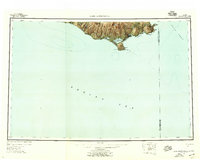
1952 Map of Cape Mendenhall
USGS Topo · Published 1958About this map
Nunivak Island dominates this mid-century survey of the southern coast where the Bering Sea meets the Etolin Strait. The topography is defined by significant coastal sand formations, including the Nunathloogagamiutbingoi Dunes and Bangookbit Dunes, which wrap around the shoreline towards the prominent southern point of Cape Mendenhall. The map documents traditional habitation sites such as Kiyukyalikamiut and Nakooytoolekmiut, reflecting the presence of indigenous settlements within what is now the Nunivak National Wildlife Refuge. The interior landscape rises toward landmarks like Ingrijioak Hill and Jayalik Hill, drained by the Chakwakamiut River and punctuated by Kuyun Lake. This chart also captures the maritime boundary between the Second and Fourth Judicial Divisions, marking a specific moment in Alaska's administrative history.
Find a feature on this map
23 named features on this map. Tap any name to fly to it.
Don’t see what you’re looking for? This feature index may not catch every label — zoom into the map to look around manually.
Map Details
Editions of this 1952 Cape Mendenhall Map
5 editions found
Other maps of this area

1951 · Kuskokwim Bay
USGS Topo · 1:250,000

1951 · Cape Mendenhall
USGS Topo · 1:250,000

1951 · Nunivak Island
USGS Topo · 1:250,000

1951 · Baird Inlet
USGS Topo · 1:250,000

1952 · Cape Mendenhall D-4
USGS Topo · 1:63,360

1952 · Cape Mendenhall D-3
USGS Topo · 1:63,360

1952 · Nunivak Island A-4
USGS Topo · 1:63,360

1952 · Nunivak Island A-7
USGS Topo · 1:63,360

1952 · Cape Mendenhall
USGS Topo · 1:250,000

1952 · Cape Mendenhall D-6
USGS Topo · 1:63,360