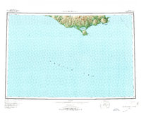
1952 Map of Cape Mendenhall
USGS Topo · Published 1973About this map
Nunivak Island National Wildlife Refuge dominates the southern reaches of this Bering Sea landscape, showing a complex coastal environment of dunes, lagoons, and isolated peaks. This mid-century survey documents the transition between the rugged volcanic interior and the surrounding waters of the Bering Sea and Etolin Strait. Researchers interested in Indigenous place names and historical land use will find the Nakootyoolekmiut (Site) near the eastern coast, along with extensive dune systems like the Bangookbit Dunes and Nunathloogagamutbingoi Dunes.
Find a feature on this map
24 named features on this map. Tap any name to fly to it.
Don’t see what you’re looking for? This feature index may not catch every label — zoom into the map to look around manually.
Map Details
Editions of this 1952 Cape Mendenhall Map
5 editions found
Other maps of this area

1951 · Kuskokwim Bay
USGS Topo · 1:250,000

1951 · Cape Mendenhall
USGS Topo · 1:250,000

1951 · Nunivak Island
USGS Topo · 1:250,000

1951 · Baird Inlet
USGS Topo · 1:250,000

1952 · Cape Mendenhall D-4
USGS Topo · 1:63,360

1952 · Cape Mendenhall D-3
USGS Topo · 1:63,360

1952 · Nunivak Island A-4
USGS Topo · 1:63,360

1952 · Nunivak Island A-7
USGS Topo · 1:63,360

1952 · Cape Mendenhall
USGS Topo · 1:250,000

1952 · Cape Mendenhall D-6
USGS Topo · 1:63,360