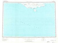
1952 Map of Cape Mendenhall
USGS Topo · Published 1973About this map
The southern coastline of Nunivak Island is the focus of this mid-century survey, dominated by the sweeping boundaries of the Nunivak Island National Wildlife Refuge. The landscape is defined by its coastal hydrology, where numerous rivers such as the Binajoakamiut River and Duckhikmiut River drain into the Bering Sea. Geographic landmarks like Cape Mendenhall and Atahgo Pt punctuate the shore, while the interior reveals volcanic origins at the Iliakvat Lava Bed and a nearby Crater.
Find a feature on this map
28 named features on this map. Tap any name to fly to it.
Don’t see what you’re looking for? This feature index may not catch every label — zoom into the map to look around manually.
Map Details
Editions of this 1952 Cape Mendenhall Map
5 editions found
Other maps of this area

1951 · Kuskokwim Bay
USGS Topo · 1:250,000

1951 · Cape Mendenhall
USGS Topo · 1:250,000

1951 · Nunivak Island
USGS Topo · 1:250,000

1951 · Baird Inlet
USGS Topo · 1:250,000

1952 · Cape Mendenhall D-4
USGS Topo · 1:63,360

1952 · Cape Mendenhall D-3
USGS Topo · 1:63,360

1952 · Nunivak Island A-4
USGS Topo · 1:63,360

1952 · Nunivak Island A-7
USGS Topo · 1:63,360

1952 · Cape Mendenhall
USGS Topo · 1:250,000

1952 · Cape Mendenhall D-6
USGS Topo · 1:63,360